Recreation Information |
|
Current Recreation News
Keep abreast of recreation developments, including reports and background information, at our special page on the JAG Recreation Committee. To make your own comments on recreation issues, visit the Jackson Forum. 2010 Logging Operation Closures Logging has resumed in Jackson Forest. Areas where logging occurs are closed to recreation use.
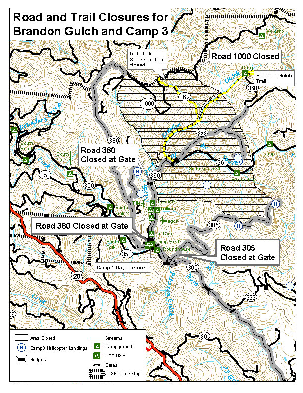
The Camp 6 and Indian Springs campgrounds shall be closed.
Check with Jackson Headquarters (707 964-5674) if you have questions about recreation in the vicinity of harvest operations.
Hikes In Jackson Forest During 2000-2003, Nancy McCarthy created and led a number of hikes in Jackson Forest. Descriptions and maps of eleven of these hikes are now available at www.MendoWalks.org , thanks to Michael Potts. There is a great hike in Jackson Forest only a few miles from Mendocino Village, on informal trails created by Kendrick Petty, a local resident. Map and directions. See also, a map showing common trails and loops used by horse riders, cyclists, and hikers. This is a work in progress and the map shown is an initial draft without supporting details. The map will be most useful if you have a browser or software that will allow you to zoom in to see map details. Camping and Recreation Maps New Jackson Map AvailableJackson Forest management has produced a new, large-scale map of Jackson Forest. This is an essential map for navigating the roads, camps, and trails in Jackson Forest. This is the first new map produced in many years. Not only is updated and with topographical information, it is printed on durable plasticized paper -- and it is only $5.00. Available at JDSF offices, 408 North Main Street, Fort Bragg. Camping Camping in Jackson Forest is no longer free. The current fee (as of 2012) is $15 per night. The maximum uninterrupted stay is two weeks, with one month total per calendar year. See Online Maps, below, for location. Online Maps Available here are maps of east and west sections of Jackson State Forest, showing roads and camping sites. Most camp sites are in the Camp One area. Trail Map An inventory of commonly used hiking, biking, and equestrian trails is currently being made by users of the forest. A preliminary map showing common trails and loops has been created. More information and details on the trails will be forthcoming. The map will be most useful if you have a browser or software that will allow you to zoom in to see map details.
Bike Rides Local bikers are generously sharing
their knowledge of its many miles of biking trails -- both single and
double track, some moderate, some challenging, some difficult climbs, and
some very rutted descents. They will be happy to take
individuals and/or groups of up to 15-20
on either beginning, intermediate, or advanced rides, depending on who
shows up. Visitors may check the Archives for the next ride time and meeting place for rides. Usually we meet at 1 PM Tuesdays and Thursdays and 10 AM Sundays.
|